

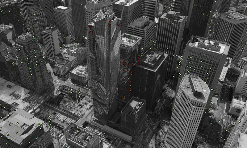
Data from the Sentinel-1 satellites acquired between 22 February 2015 and 20 September 2016 show that Millennium Tower in San Francisco is sinking by about 40 mm a year in the ‘line of sight’ – the direction that the satellite is ‘looking’ at the building. This translates into a vertical subsidence of almost 50 mm a year, assuming no tilting. The coloured dots represent targets observed by the radar. The colour scale ranges from 40 mm a year away from radar (red) to 40 mm a year towards radar (blue). Green represents stable targets. Credit: Contains modified Copernicus Sentinel data (2015–16) / ESA SEOM INSARAP study / PPO.labs / Norut / NGU
“The Sentinel-1 satellites have shown that the Millennium Tower skyscraper in the centre of San Francisco is sinking by a few centimetres a year. Studying the city is helping scientists to improve the monitoring of urban ground movements, particularly for subsidence hotspots in Europe.
“Completed in 2009, the 58-storey Millennium Tower has recently been showing signs of sinking and tilting. Although the cause has not been pinpointed, it is believed that the movements are connected to the supporting piles not firmly resting on bedrock.
“To probe these subtle shifts, scientists combined multiple radar scans from the Copernicus Sentinel-1 twin satellites of the same area to detect subtle surface changes – down to millimetres. The technique works well with buildings because they better reflect the radar beam.
“It is also useful for pinpointing displacement hotspots over large areas, thanks to Sentinel-1’s broad coverage and frequent visits.
“Working with ESA, the team from Norut, PPO.labs and Geological Survey of Norway have also mapped other areas in the wider San Francisco Bay Area that are moving. These include buildings along the earthquake-prone Hayward Fault, as well as subsidence of the newly reclaimed land in the San Rafael Bay.
“An uplift of the land was detected around the city of Pleasanton, possibly from the replenishment of groundwater following a four-year drought that ended in 2015.
Text and Pic: Satellites confirm sinking of San Francisco tower, Physics.org
